Faculty Research
Our faculty members provide students with the tools they need to thrive after graduation because of their own passion for planning, GIS, and design research.
Research informs teaching and brings the real-world impact of our faculty and students to classroom discussions and student assignments.
The School's faculty have expertise in economic development, land use planning, environmental and health planning, urban design, housing and community development, transportation planning, geographic information systems, and urban analytics. They've worked with non-profit, governmental, and for-profit agencies and organizations around Atlanta, other cities in the US, and internationally.
If you would like to get involved in a research project, please talk to one of the program directors, the research center or research lab directors, or to the chair.
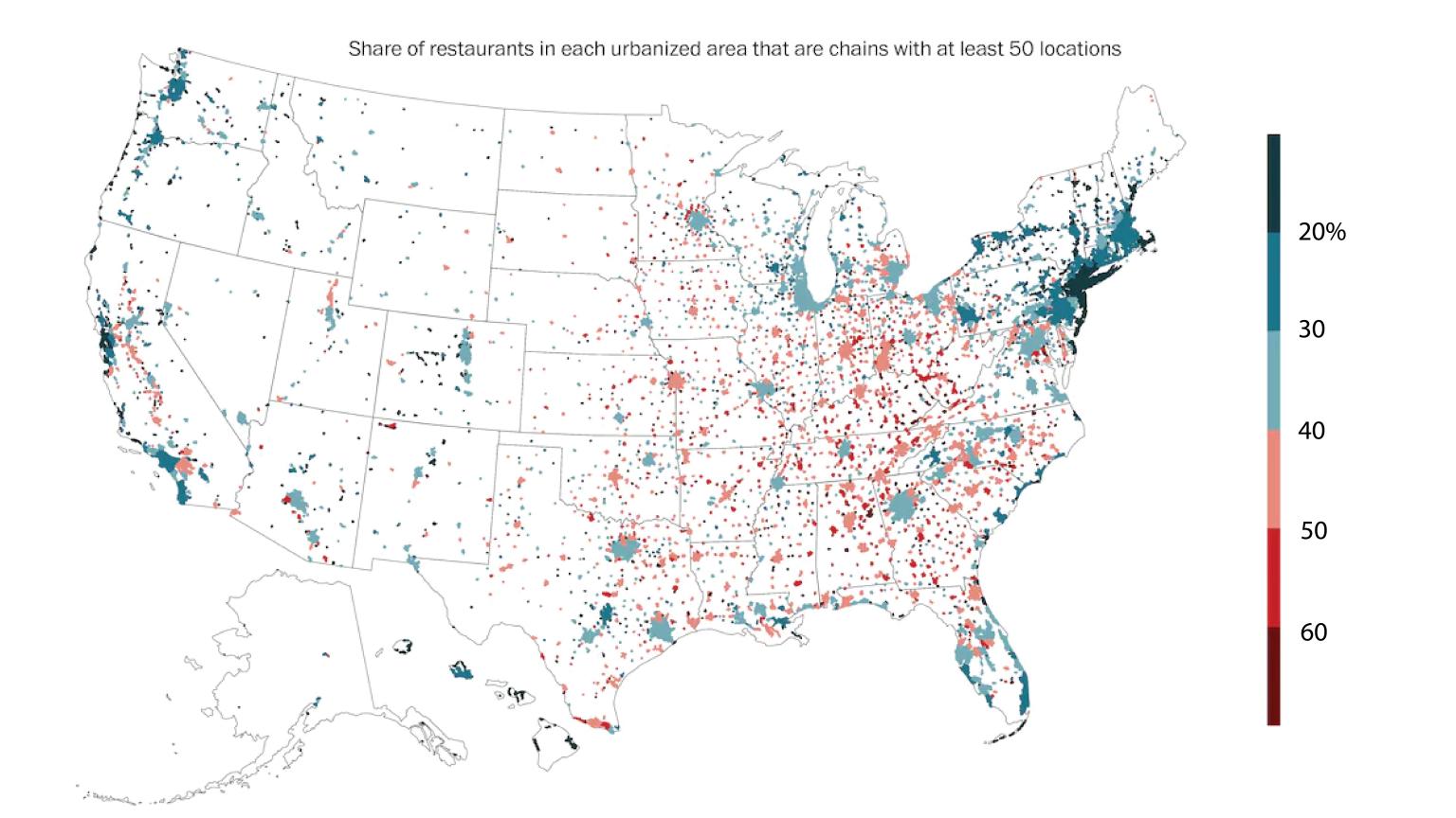
Food Culture and Social Landscapes
The research article was featured in Washington Post
The research explored which types of locales have an independent food culture and which resemble McCities: foodscapes where the food offerings can be found just as easily in one place as in many other (often distant) places. The research found that car-dependency, low walkability, high percentage voters for Donald Trump (2016), concentrations of college-age students, and nearness to highways were associated with high rates of 'chainness'. These novel findings open new pathways for measuring social landscapes in the United States through retail offerings.
This project was led by Xiaofan Liang, PhD student in the School of City and Regional Planning and her doctoral advisor Clio Andris, Associate Professor of City and Regional Planning and Interactive Computing.

Robot Adoption among US Manufacturers
Working collaboration with the Montgomery County Planning Department
Being in a region with a large pool of existing robot users and robot-related skills labor positively affects establishments' decisions on robot adoption. The novel research highlighted robot adoptions in often small- and medium-sized establishments. The research noted the knowledge gap of robot adoptions in these establishments were often perpetuated by uneven spatial distribution of other establishments that apply robot adoption as well as robot suppliers.
Nancey Green Leigh is a Professor at the School of City and Regional Planning. Dr. Leigh also serves as an Associate Dean for Research at the College of Design as well as an ADVANCE Professor.
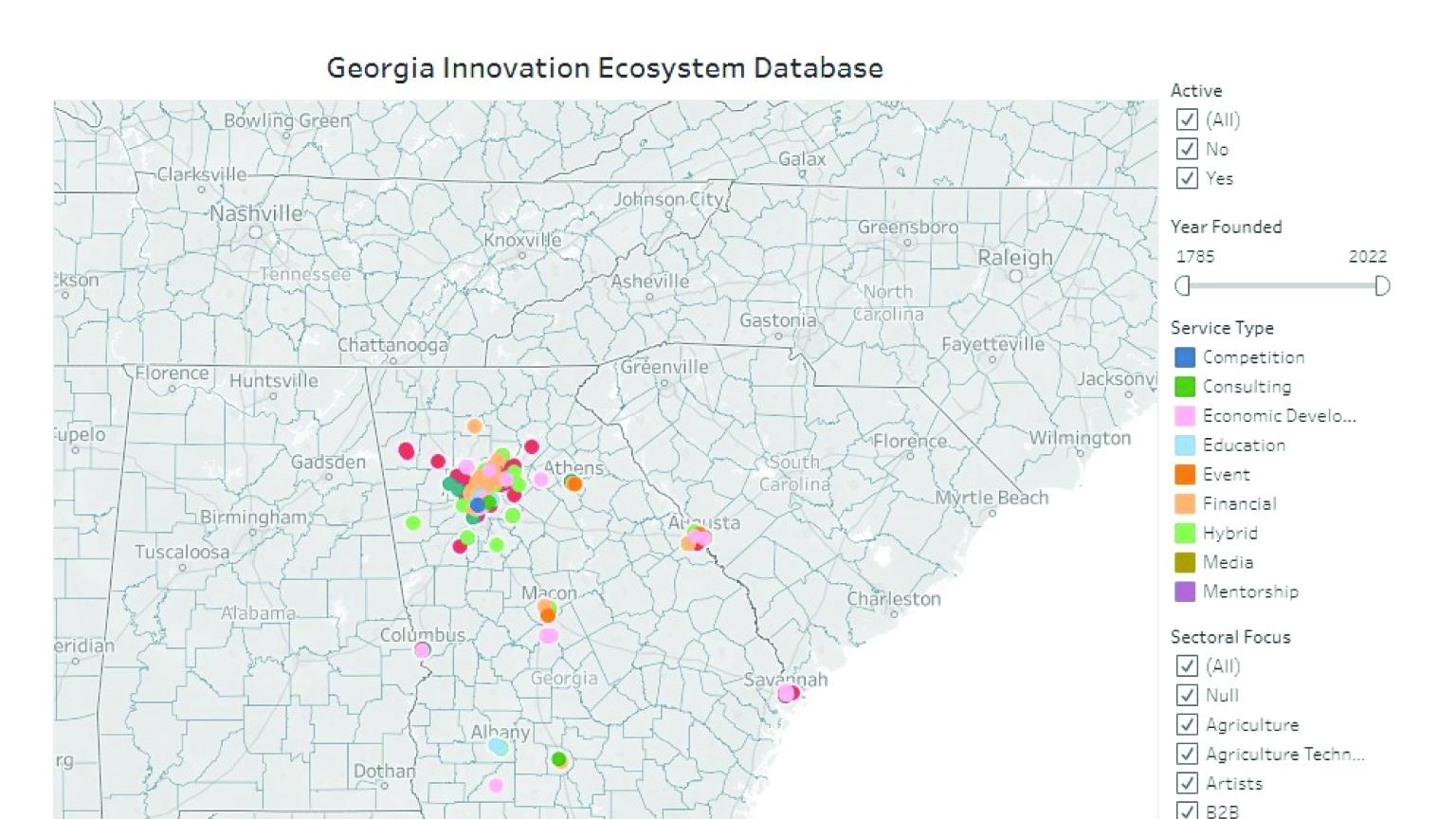
Database on Entrepreneurship in Georgia
with the CREATE Research Center at UNC Chapel Hill
The PLatform for Advancing Community Economies (PLACE) Database was created at UNC Chapel Hill by PIs Maryann Feldman and (until 2018) Nichola Lowe. The original PLACE Database is currently housed under the CREATE Research Center at the Kenan Institute of Private Enterprise at UNC Chapel Hill. The UNC Renaissance Computing Institute hosts the MySQL database on local servers and maintains the site. As part of the team that developed this relational database, including using over 30 sources to triangulate longitudinal data on entrepreneurship in regional economies and develop database fields and search methodologies, Dr. Clayton is spearheading the efforts of replicating and expanding this work to cover the state of Georgia.
Paige Clayton is an Assistant Professor at the School of City and Regional Planning.
Large Corporate Landlords' Impact on Renters
funded by the Housing Crisis Research Collaborative at the Urban Institute
The research team investigate the ongoing consolidation of single-family rental sector by large corporate landlords, and the consequences for renters and neighborhoods. Early research uncovered the high eviction rate of large corporate landlords, and the way in which policymakers supported the creation of single-family rental securitization, encouraging the rise of private equity and institutional investor presence in this sector. In ongoing research funded by the Housing Crisis Research Collaborative at the Urban Institute, we describe how large corporate landlords and private equity firms invested in Tampa, Miami, and Atlanta during the pandemic. We find that rent-to-own investors, and large corporate single family rental firms increased purchases in these three southeastern cities during the pandemic, and increasingly focused in areas that were hardest hit by COVID19 and had the greatest housing instability risk. These firms’ purchases were concentrated in low-poverty Black and non-white Hispanic neighborhoods.
Elora Raymond is an Assistant Professor at the School of City and Regional Planning.
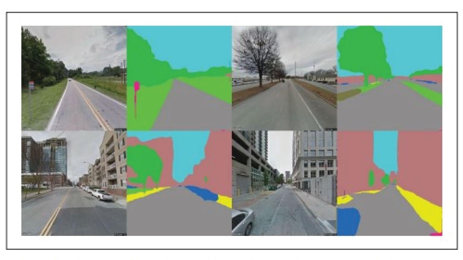
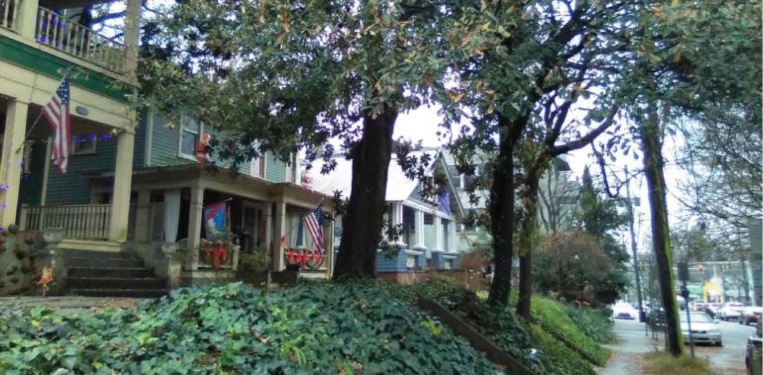
Street View Images as measure of walkability
The paper was published in Environment and Behaviour journal
The novel paper uses computer vision to quantify street-level factors from street views images in Atlanta, Georgia. Correlation analysis shows that some streetscape factors are highly correlated with neighborhood-level factors. This work could further push boundaries of image-based streetscape factors as a proxy for some macroscale factors while representing the pedestrian experience as seen from eye-level.
This project was a working collaboration between Bonwoo Koo, Postdoctoral Researcher at Center for Spatial Analytics and Visualization at Georgia Institute of Technology; Subhrajit "Subhro" Guhathakurta, Professor at School of City and Regional Planning; and Nisha Botchwey of University of Minnesota, who has previously served as a faculty in the School of City and Regional Planning.
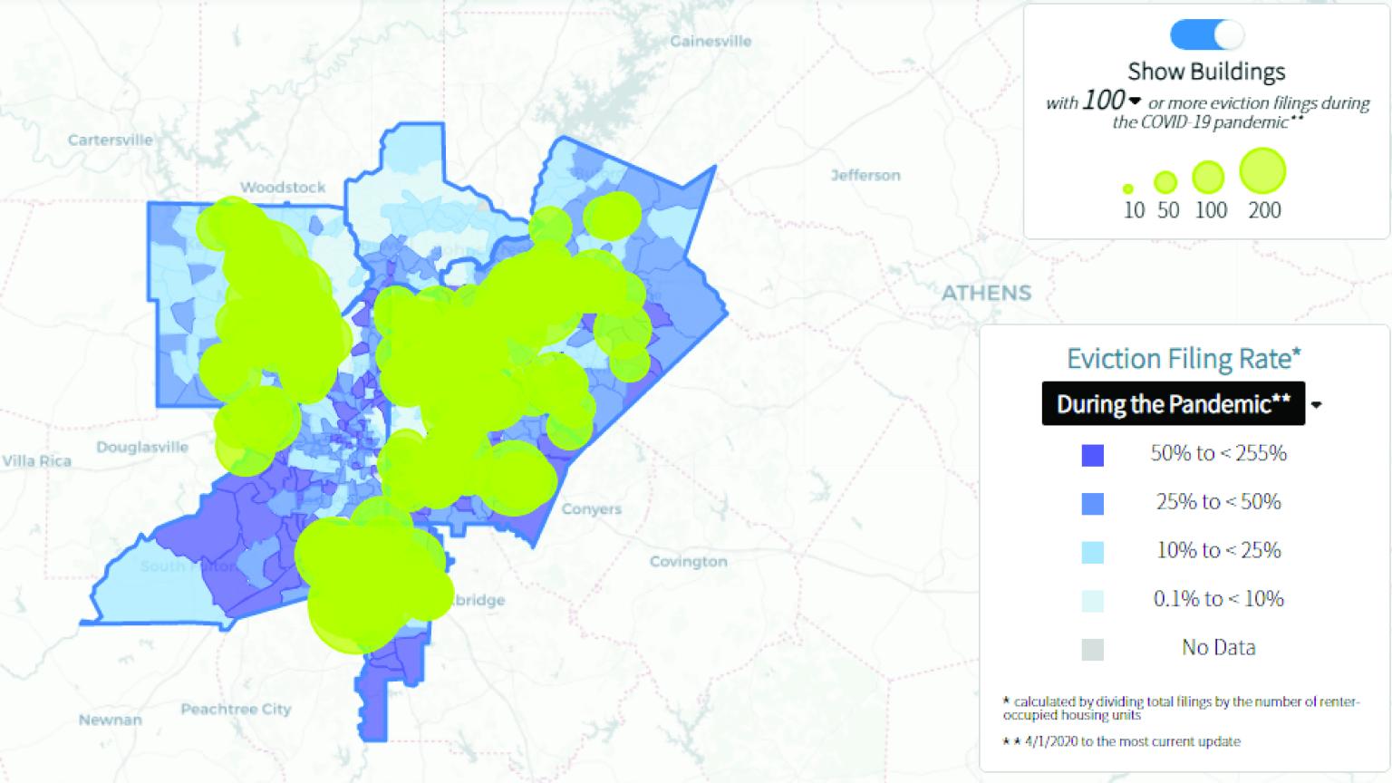
Partnership Launches Atlanta Region Eviction Tracker
with Federal Reserve Bank of Atlanta, Atlanta Regional Commission, and CSPAV
Several partnering organizations in Atlanta came together to create a database of eviction filings. Their goal is to provide information to constituents and decision makers about the state of eviction-related housing instability, particularly in the context of the Covid-19 pandemic.
This project was led by Elora Lee Raymond, Assistant Professor in the School of City and Regional Planning; the Center for Spatial Planning Analytics and Visualization (CSPAV); the Federal Reserve Bank of Atlanta; and the Atlanta Regional Commission.
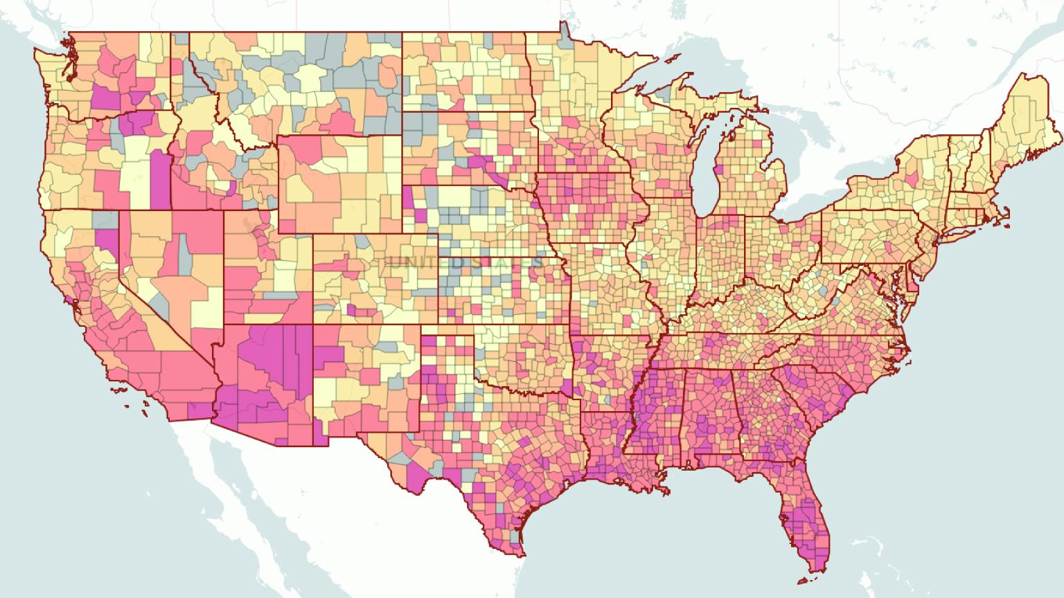
County-Level Calculator Estimates Risk of Covid-19 Exposure
An interactive dashboard that estimates Covid-19 incidence at gatherings in the U.S. has added a new feature: the ability to calculate county-level risk of attending an event with someone actively infected with Coronavirus (Covid-19). Previously, the dashboard estimated exposure for different size events by state.
Since April, Assistant Professor Clio Andris and her Friendly Cities Lab have worked with Joshua Weitz, professor in the School of Biological Sciences, to create a Covid-19 model that accounted for spatial interaction.
Recent Faculty Publications
Our faculty publish books, book chapters, and refereed journal articles that are highly respected and well-read throughout the planning community and beyond.
- "Points of Interest (POI): a commentary on the state of the art, challenges, and prospects for the future" Andris, Clio
- "Measuring McCities: Landscapes of chain and independent restaurants in the United States" Andris, Clio
- "Dissecting diffusion: Tracing the plurality of factors that shape knowledge diffusion" Clayton, Paige
- "Accelerator niches in an emerging entrepreneurial ecosystem: New York City" Clayton, Paige
- "Exploring the Impact of Bike Lanes on Transportation Mode Choice: A simulation-based, route-level impact analysis" Guhathakurta, Subhro
- "How are neighborhood and street-level walkability factors associated with walking behaviors? A big data approach using street view images" Guhathakurta, Subhro
- "Disparities in robot adoption among US manufacturers: a critical economic development challenge" Leigh, Nancey Green
- "Millennial first-time homebuyers and location choice" Raymond, Elora
- "Compound climate and infrastructure events: how electrical grid failure alters heat wave risk" Stone Jr., Brian
- "Climate change and infrastructure risk: Indoor heat exposure during a concurrent heat wave and blackout event in Phoenix, Arizona" Stone Jr., Brian
- "Planning decentralized urban renewable energy systems using algal cultivation for closed-loop and resilient communities" Yang, Perry
- "Green recovery planning from COVID for a low energy urban district using urban digital platform–A case study of Tokyo Shinagawa" Yang, Perry